Difference between revisions of "Term data entry"
m |
|||
| (10 intermediate revisions by 2 users not shown) | |||
| Line 2: | Line 2: | ||
| − | == | + | == Definition area == |
| + | |||
| + | === Taxonomy === | ||
| + | |||
| + | This [[Glossary#Field|field]] is completed automatically according to the name of the [[Glossary#Taxonomy|taxonomy]] to which the [[Glossary#Term|term]] belongs. | ||
| − | |||
| + | === Name === | ||
| − | + | Enter the name of the [[Glossary#Term|term]] as you would like to see it appear in value lists in [[Glossary#Edit page|edit page]] and as labels in [[Glossary#View page|view page]]. | |
| − | |||
| + | === Use for === | ||
| − | + | You can create one or more non-preferred [[Glossary#Term|terms]] using this [[Glossary#Field|field]]. When users attempt to add the non-preferred [[Glossary#Term|term]] to a record the preferred [[Glossary#Term|term]] will be added instead. Similarly, if users search on the non-preferred [[Glossary#Term|term]], ICA-AtoM will automatically substitute the preferred [[Glossary#Term|term]]. | |
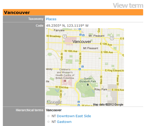
| + | [[Image:code_field_vancouver_example.png|500px|right|thumb|An example of a map generated using Google's Static Map API by placing latitudes and longitudes in the Code data entry field.]] | ||
| − | + | === Code === | |
| + | This field is under development. Currently, it allows [[Glossary#Administrator|administrators]] and [[Glossary#Editor|editors]] to add a static [http://maps.google.com/ Google Map] to a Place [[Glossary#Term|term]] description. The field behaves similarly to the search bar on a Google Map, and will generate a static map image based on the term entered using [https://developers.google.com/maps/documentation/staticmaps/ Google's Static Map API.] Terms entered can include addresses, latitude/longitude coordinates, and place names (such as cities, neighborhoods, etc.). Unlike Google Maps, a pin will not be added to the map to mark the selected location, and currently the user cannot specify the scale of the map generated. At the moment, the map is only viewable through the taxonomy "view term" screen available to administrators and editors. | ||
| − | == Scope note == | + | === Scope note(s) === |
Enter descriptive information about the [[Glossary#Term|term]]. | Enter descriptive information about the [[Glossary#Term|term]]. | ||
| − | + | === Source note(s) === | |
| − | == Source note == | ||
Enter the source of the [[Glossary#Term|term]] if applicable. | Enter the source of the [[Glossary#Term|term]] if applicable. | ||
| − | + | === Display note(s) === | |
| − | == Display note == | ||
Enter an alternate label for the [[Glossary#Term|term]] if applicable. | Enter an alternate label for the [[Glossary#Term|term]] if applicable. | ||
| Line 37: | Line 41: | ||
</div> | </div> | ||
| + | == Relationships area == | ||
| − | + | See [[Hierarchical taxonomies]] | |
| − | |||
| + | [[Category:User manual]] | ||
| − | + | __NOTOC__ | |
Latest revision as of 15:03, 31 May 2012
Please note that ICA-AtoM is no longer actively supported by Artefactual Systems.
Visit https://www.accesstomemory.org for information about AtoM, the currently supported version.
Main Page > User manual > Add/edit content > Add/edit terms > Term data entry
Definition area
Taxonomy
This field is completed automatically according to the name of the taxonomy to which the term belongs.
Name
Enter the name of the term as you would like to see it appear in value lists in edit page and as labels in view page.
Use for
You can create one or more non-preferred terms using this field. When users attempt to add the non-preferred term to a record the preferred term will be added instead. Similarly, if users search on the non-preferred term, ICA-AtoM will automatically substitute the preferred term.
Code
This field is under development. Currently, it allows administrators and editors to add a static Google Map to a Place term description. The field behaves similarly to the search bar on a Google Map, and will generate a static map image based on the term entered using Google's Static Map API. Terms entered can include addresses, latitude/longitude coordinates, and place names (such as cities, neighborhoods, etc.). Unlike Google Maps, a pin will not be added to the map to mark the selected location, and currently the user cannot specify the scale of the map generated. At the moment, the map is only viewable through the taxonomy "view term" screen available to administrators and editors.
Scope note(s)
Enter descriptive information about the term.
Source note(s)
Enter the source of the term if applicable.
Display note(s)
Enter an alternate label for the term if applicable.
In the current version of ICA-AtoM, this field applies only to the events taxonomy. For example, for the term "distribution" the display note is "distributor".
Relationships area
